
The Mechanics of Real Time Satellite Tracking
Modern life depends on satellites, yet they remain invisible to the naked eye. Discover how to monitor orbital mechanics and track satellites in real time using accessible data and tools.
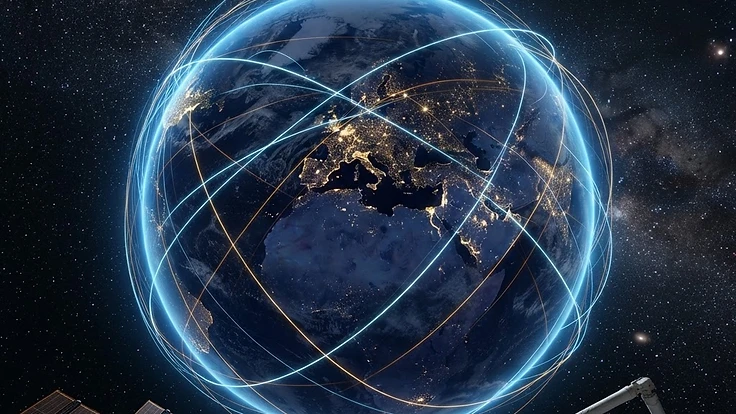
The Mechanics of Real Time Satellite Tracking
Thousands of satellites currently orbit our planet, forming an invisible web that supports global communications, navigation, and environmental monitoring. Despite their importance, most people rarely consider the complex machinery hurtling just a few hundred kilometres above their heads at thousands of kilometres per hour. Tracking these objects requires an understanding of orbital mechanics and access to real time telemetry data.
Learning to follow these paths transforms our view of the night sky from a static tapestry into a dynamic arena of human activity. It allows observers to predict when a satellite will pass overhead or understand how external forces, such as space weather, affect orbital paths. This pursuit bridges the gap between amateur astronomy and professional space situational awareness.
The Science Behind It
Satellites stay aloft by balancing gravitational pull with their own tangential velocity. This speed ensures they are effectively falling around the Earth rather than toward it, maintaining a stable trajectory at altitudes ranging from the Low Earth Orbit of the ISS at roughly 408 kilometres to distant geostationary positions. Tracking them relies on precise mathematical models known as Two-Line Element sets, or TLEs.
These datasets provide the necessary parameters to calculate an object's position at any given time. However, satellites are not immune to the environment of space. Solar activity can cause the atmosphere to expand, increasing drag on objects in lower orbits.
Monitoring the K-index helps researchers understand how geomagnetic storms influence satellite drag and orbital decay over time.
Real-World Implications
Accurate tracking is essential for collision avoidance and protecting our orbital infrastructure. As the growing density of space debris in orbit continues to challenge operators, real time data becomes the primary defence against potential impacts. A single collision could create a cascade of fragments, endangering functioning satellites and future missions.
Beyond safety, tracking allows us to manage the impact of solar events on our technological systems. When a severe geomagnetic storm occurs, operators must be prepared to adjust satellite orientation or power down sensitive components. Studying these effects helps us refine the models used in the solar cycle and the dynamics of space weather, ensuring that our reliance on space-based technology remains sustainable.
What You Can Do
Beginners can start by using freely available tracking software or web platforms that visualise these complex orbital paths. You do not need expensive hardware to participate, as many resources now provide live, high-fidelity data that you can easily follow on your own device. To make this information more accessible for your own projects, consider using embeddable widgets that display real time orbital data directly on your personal website or dashboard.
If you want to understand how your local environment interacts with these space-based systems, checking your [local aurora forecast](/#local) can provide insights into how ionospheric disturbances might affect satellite signals. These tools help you see the connection between the ground and the stars. Whether you are observing for scientific interest or technical preparedness, the ability to monitor the sky is now at your fingertips.
If you'd rather trade the dashboard for a guide, aurora hunting tours in Iceland, Sweden and Canada pair real-time Kp monitoring with local knowledge of clear-sky microclimates.
Key Takeaways
Tracking satellites connects us to the infrastructure that powers our modern world. By understanding how orbital mechanics work and how environmental factors like solar radiation impact these paths, we gain a deeper appreciation for the space age. This practice moves beyond simple observation, allowing us to engage with the reality of our position in the solar system.
As we continue to launch more satellites and expand our reach into orbit, maintaining an accurate picture of the space environment will remain a vital task. Consistent monitoring keeps us informed about the status of our technological assets. Stay curious about the heavens and continue to explore the data that maps our path through the dark.
People Also Ask
What is a TLE in satellite tracking?+
A Two-Line Element set is a data format used to describe the orbital elements of an object in Earth orbit. It provides the specific parameters required by mathematical models to predict where a satellite will be at any given moment, making it the standard for tracking orbital assets.
Why do satellites need to be tracked?+
Satellites must be tracked primarily to prevent collisions with other space objects and to manage orbital maintenance. Tracking also helps operators account for atmospheric drag, which can change a satellite's position unexpectedly, ensuring that essential communication and navigation services remain reliable and safe for everyone on Earth.
Can I see satellites with the naked eye?+
Yes, many satellites are visible to the naked eye, especially if they are large or have reflective surfaces. The best time to spot them is shortly after sunset or before sunrise when the satellite is illuminated by the sun while the observer on the ground remains in darkness.
Continue Reading
Forecast These Questions
View all →Express your probability on these active forecast questions.
Related Articles

Satellite Operators Use Advanced Strategies to Mitigate Space Weather Risks
2026-11-10 · 5 min read

Understanding the Mechanics of Sun-Synchronous Orbits
2026-10-16 · 5 min read

Tracking the International Space Station in Real Time
2026-10-02 · 5 min read