
Tracking Satellites Across the Night Sky
Modern satellite tracking bridges the gap between complex orbital mechanics and amateur observation. Learn how to monitor thousands of artificial objects orbiting our planet.
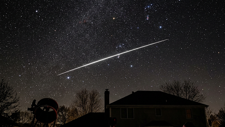
Tracking Satellites Across the Night Sky
Thousands of satellites orbit the Earth at any given moment, silently relaying data for communications, weather monitoring, and scientific research. While these objects are often invisible to the naked eye, modern technology makes it possible for anyone to follow their paths in real time. Understanding how these machines move provides a unique perspective on our proximity to the space environment.
Tracking serves as a vital bridge between the abstract math of orbital mechanics and the physical reality of human activity in space. Whether you are an amateur astronomer or someone interested in the health of our orbital infrastructure, knowing where these satellites are helps demystify the busy sphere of low Earth orbit.
The Physics of Orbital Motion
Satellites stay in the sky because they balance the forward velocity of their orbit against the constant pull of Earth gravity. An object like the ISS, maintaining an altitude of roughly 408 km, must travel at high speeds to remain in stable flight. These orbits are governed by Keplerian laws, which dictate how objects move around a primary mass like the Earth.
Tracking software uses two-line element sets, or TLEs, to predict the future position of a satellite. These data points provide a snapshot of the orbital parameters at a specific moment. By accounting for perturbations like atmospheric drag and the non-spherical shape of the Earth, computers can project these paths forward with impressive accuracy.
Satellites do not always remain immune to the environment they inhabit. Solar activity can influence the density of the upper atmosphere, which increases drag and can force operators to adjust satellite altitudes. You can explore how solar flares and the reliability of satellite navigation systems highlight our dependence on stable orbital paths.
Real-World Implications
Satellite tracking is not just a hobby, as it underpins many aspects of modern life. Reliable positioning data allows for the management of the growing congestion in space, reducing the risk of collisions. As more companies launch constellations of small satellites, the ability to monitor their behaviour becomes a matter of long-term space safety.
These systems also serve as a warning mechanism when natural space weather interferes with operations. When the [Kp](/ #kp) index rises, representing higher geomagnetic disturbance, orbital decay rates can accelerate for satellites in lower orbits. This direct link between solar output and hardware health makes tracking an essential component of professional space situational awareness.
What You Can Do
To start tracking satellites, you need access to reliable data feeds and user-friendly software interfaces. Numerous web-based tools allow you to input your coordinates and receive predictions on when a specific satellite will pass overhead. Many enthusiasts also use embeddable widgets on their own websites to provide live updates for their communities.
If you prefer to see the results of your tracking in a visual format, keeping an eye on solar imagery provides context for the conditions satellites are currently facing. Preparing for these observations can be as simple as setting up alerts for specific orbital passes. You can find more detailed explanations of these phenomena in our blog to deepen your understanding of the technology involved.
Key Takeaways
Tracking satellites is a practical way to engage with the reality of our technological footprint in orbit. By understanding the mechanics of orbital decay and the influence of space weather, we gain a clearer view of the challenges facing our satellite networks. It is a rewarding pursuit that turns the invisible infrastructure of the modern age into a visible subject of study.
Regular monitoring allows us to appreciate the delicate balance of satellite operations. Whether you are tracking individual craft or watching for signs of environmental impact, these tools keep you connected to the frontier above. The vast network surrounding our planet continues to grow, making tracking a more relevant skill every year.
People Also Ask
What are TLEs in satellite tracking?+
TLE stands for Two-Line Element set. It is a data format that describes the orbital elements of an orbiting object at a specific point in time. Tracking software uses these elements to calculate the predicted position of a satellite at any time in the future.
Why does space weather affect satellite orbits?+
Space weather, specifically solar activity, causes the Earth atmosphere to heat up and expand. This increases the density of the air at satellite altitudes, which creates more atmospheric drag. This drag slows down satellites, causing them to lose altitude and potentially drift from their intended orbit.
Can I see satellites with the naked eye?+
Yes, many large satellites like the ISS are easily visible to the naked eye. They look like steady, bright stars moving quickly across the sky. Because they reflect sunlight, the best time to see them is shortly after sunset or before sunrise when the observer is in darkness but the satellite is not.
Continue Reading
Forecast These Questions
View all →Express your probability on these active forecast questions.
Related Articles

Satellite Operators Use Advanced Strategies to Mitigate Space Weather Risks
2026-11-10 · 5 min read

Understanding the Mechanics of Sun-Synchronous Orbits
2026-10-16 · 5 min read

Tracking the International Space Station in Real Time
2026-10-02 · 5 min read